


Important eventsBack
The start of Lewis and Clark Expedition14.5.1804
The expedition took place shortly after the Louisiana Purchase in 1803, was commissioned by President Thomas Jefferson and consisted of a select group of U.S. Army volunteers under the command of Captain Meriwether Lewis and his close friend Second Lieutenant William Clark. The duration of their perilous journey lasted from May 1804 to September 1806. The primary objective was to explore and map the newly acquired territory and, by following the Missouri river northwest to see if it was connected or came close enough to the Columbia river, which flowed on to the Pacific Ocean. During this exploration Lewis and Clark aimed to find a practical route across the Western half of the continent, and in doing so, to establish an American presence in this territory thus securing it before Britain and other European powers tried to claim it.
The campaign's secondary objectives were scientific and economical: to study the area's plants, animal life, geography, and other natural resources. During the course of the journey the expedition discovered many additional rivers and lakes along with numerous Indian tribes, many of whom they traded with and obtained useful information from. With maps, sketches and journals in hand, Lewis, Clark, and the other members of the expedition returned to St. Louis in September 1806 to report their findings to Jefferson.Overview
According to Jefferson himself, one goal was to find "the most direct & practicable water communication across this continent, for the purposes of commerce". Jefferson also placed special importance on declaring U.S. sovereignty over the land occupied by the many different tribes of Native Americans along the Missouri River, and getting an accurate sense of the resources in the recently completed Louisiana Purchase.
Although the expedition did make notable contributions to science, scientific research itself was not the main goal of the mission.
References to Lewis and Clark "scarcely appeared" in history books even during the United States Centennial in 1876 and the expedition was largely forgotten. Lewis and Clark began to gain new attention around the start of the 20th century. Both the 1904 Louisiana Purchase Exposition, in St. Louis, and the 1905 Lewis and Clark Centennial Exposition, in Portland, Oregon, showcased Lewis and Clark as American pioneers. However, the story remained relatively shallow—a celebration of US conquest and personal adventures—until the mid-century, since which time it has been more thoroughly researched and retold in many forms to a growing audience.
In addition, a complete and reliable set of the expedition's journals was finally compiled by Gary E. Moulton. In the 2000s the bicentennial of the expedition further elevated popular interest in Lewis and Clark. Today, no U.S. exploration party is more famous, and no American expedition leaders are more instantly recognizable by name.
Preparations
For years Jefferson had heard of and read accounts of the various ventures of other explorers in parts of the western frontier and consequently had a long held interest in further exploring this largely still unknown region of the continent. In the 1780s, while Minister to France, Jefferson met John Ledyard in Paris and discussed a proposed trip to the Pacific Northwest. Jefferson had also read Captain James Cook's A Voyage to the Pacific Ocean (London, 1784) an account of Cook's third voyage, and Le Page du Pratz'z The History of Louisiana ...(London, 1763) all of which greatly influenced his decision to send an expedition. Like Captain Cook, Jefferson also wished to discover a practical route through the Northwest to the Pacific coast. However it was Alexander Mackenzie's publication of 1801, Voyages from Montreal, which revealed to Jefferson, who had read the book at Monticello in 1802, of Britain's declaration of its intent to control the lucrative fur trade of the Columbia River, that convinced him of the importance of securing the territory as soon as possible.
Two years into his presidency, President Thomas Jefferson asked Congress to fund an expedition through the Louisiana Purchase, and to the Pacific Ocean. Jefferson didn't attempt to hide the Lewis and Clark expedition itself from Spanish, French, and British officials but rather claimed different reasons for the venture while also making similar attempts to conceal his reasons from his political enemies. He used a secret message to ask for funding due to poor relations with the opposition party in Congress.
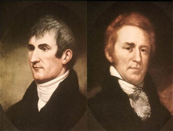
In 1803, Jefferson commissioned the Corps of Discovery, and named U.S. Army Captain Meriwether Lewis its leader, who in turn selected William Clark as second in command. Jefferson had chose Lewis to lead the expedition rather than a 'qualified scientist' because, "It was impossible to find a character who to a complete science in botany, natural history, mineralogy & astronomy, joined the firmness of constitution & character, prudence, habits adapted to the woods & a familiarity with the Indian manners and character, requisite for this undertaking. All the latter qualifications Capt. Lewis has."
Lewis demonstrated remarkable skills and potential as a frontiersman. As the expedition was gaining approval and funding Jefferson made efforts to prepare him for the long journey ahead. In 1803 under Jefferson's direction Lewis was sent to study medicinal cures under Benjamin Rush, a physician and humanitarian. Jefferson also arranged for Lewis to be further educated by Andrew Ellicott, an astronomer who instructed him in the use of the sextant and other navigational instruments. Lewis however was not ignorant of science and had demonstrated to Jefferson a marked capacity to learn, especially with Jefferson as his teacher. At Monticello Jefferson possessed the largest library in the world on the subject of the geography of the North American continent, and Lewis had full access to that library. He spent much time consulting maps and books and conferring with Jefferson on numerous topics. It was at this time Lewis had also read Captain Cook's A Voyage to the Pacific Ocean and Le Page du Pratz'z The History of Louisiana....
Lewis and Clark met near Louisville in October 1803 at the Falls of the Ohio and before departing later in the month, the core "Nine Young Men" were enlisted into the Corps of Discovery. Their goals were to explore the vast territory acquired by the Louisiana Purchase and to establish trade and U.S. sovereignty over the native peoples along the River Missouri. Jefferson also wanted to establish a U.S. claim of "Discovery" to the Pacific Northwest and Oregon territory by documenting an American presence there before Europeans could claim the land. According to some historians, Jefferson understood he would have a better claim of ownership to the Pacific Northwest if the team gathered scientific data on animals and plants. However his main objectives were centered around finding an all water route to the Pacific coast and commerce.
The U.S. mint prepared special silver medals with a portrait of Jefferson and inscribed with a message of friendship and peace, called Indian Peace Medals or peace medals. The soldiers were to distribute them to the nations they met. These symbolized U.S. sovereignty over the indigenous inhabitants. The expedition also prepared advanced weapons to display their military firepower. Among these was an air rifle of about .44 caliber, powerful enough to kill a deer.
The expedition was prepared with sufficient black powder and lead for their flintlock firearms, knives, blacksmithing supplies, and cartography equipment. They also carried flags, gift bundles, medicine and other items they would need for their journey. Much time went into ensuring a sufficient supply of these items.
The route of Lewis and Clark's expedition, took them up the Missouri River to its headwaters, then on to the Pacific via the Columbia River, and may have been influenced by the purported transcontinental journey of Moncacht-Apé by the same route about a century before. Jefferson had a copy of Le Page's book detailing Moncacht-Apé's itinerary in his library, and Lewis carried a copy with him during the expedition. Le Page's description of Moncacht-Apé's route across the continent, which neglects to mention the need to cross the Rocky Mountains, may be the source of Lewis and Clark's mistaken belief that they could easily carry boats from the Missouri's headwaters to the westward-flowing Columbia.
Journey
There were 33 people, including 29 participants in training at the 1803–1804 Camp Dubois (Camp Wood) winter staging area in Indiana Territory, near present day Wood River, Illinois. In March 1804, the Spanish in New Mexico learned from U.S. General James Wilkinson, later discovered to be a paid agent of the Spanish crown, that the Americans were encroaching on territory claimed by Spain. On August 1, they sent four armed expeditions of fifty two soldiers, mercenaries, and Indians from Santa Fe northward under Pedro Vial and José Jarvet, to intercept Lewis and Clark and imprison the entire expedition. When they reached the Pawnee settlement on the Platte River in central Nebraska they learned that the expedition had been there many days before, but because the expedition at that point was covering seventy to eighty miles a day Vial's attempt to intercept them was unsuccessful.
Departure
The Corps of Discovery departs from Camp Dubois at 4 P.M on May 14, 1804, and met up with Lewis in St. Charles, Missouri, a short time later, marking the beginning of the voyage to the Pacific coast. the corps followed the Missouri River westward. Soon they passed La Charrette, the last Euro-American settlement on the Missouri River.
The expedition followed the Missouri through what is now Kansas City, Missouri, and Omaha, Nebraska.
On August 20, 1804, Sergeant Charles Floyd died, apparently from acute appendicitis. He was the only member of the expedition to die, and was among the first to sign up with the corps of Discovery. He was buried at a bluff by the river, now named after him, in what is now Sioux City, Iowa. His burial cite was marked with a cedar post on which was inscribed his name and day of death. A mile up the river the expedition camped at a small river which they names Floyd's River. During the final week of August, Lewis and Clark reached the edge of the Great Plains, a place abounding with elk, deer, bison, and beavers.
The Lewis and Clark Expedition established relations with two dozen indigenous nations, without whose help the expedition would have risked starvation during the harsh winters and/or become hopelessly lost in the Rocky Mountains.
The Americans and the Lakota nation (whom the Americans called Sioux or "Teton-wan Sioux") had problems when they met, and there was a concern the two sides might fight. According to Harry W. Fritz, "All earlier Missouri River travelers had warned of this powerful and aggressive tribe, determined to block free trade on the river. ... The Sioux were also expecting a retaliatory raid from the Omaha Indians, to the south. A recent Sioux raid had killed 75 Omaha men, burned 40 lodges, and taken four dozen prisoners."
One of their horses disappeared, and they believed the Sioux were responsible. Afterward, the two sides met and there was a disagreement, and the Sioux asked the men to stay or to give more gifts instead before being allowed to pass through their territory. They came close to fighting several times, and both sides finally backed down and the expedition continued on to Arikara territory. Clark wrote they were "warlike" and were the "vilest miscreants of the savage race."
In the winter of 1804–05, the party built Fort Mandan, near present-day Washburn, North Dakota. One chief asked Lewis and Clark to provide a boat for passage through their national territory. As tensions increased, Lewis and Clark prepared to fight, but the two sides fell back in the end. The Americans quickly continued westward (upriver), and camped for the winter in the Mandan nation's territory.After the expedition had set up camp, nearby Indians came to visit in fair numbers, some staying all night. For several days Lewis and Clark met in council with Mandan Indian chiefs. Here they met a French-Canadian fur trapper named Toussaint Charbonneau, and his young Shoshone wife Sacagawea. Charbonneau at this time began to serve as the expedition's translator. Peace was established between the expedition and the Mandan Chiefs with the sharing of the Mandan peace pipe. By April 25 Captain Lewis wrote his progress report of the expedition's activities and observations of the Indian nations they have encountered to date: A Statistical view of the Indian nations inhabiting the Territory of Louisiana which outlined the names of various tribes, their locations, trading practices and water routes used, among other things. President Jefferson would later present this report to Congress.
They followed the Missouri to its headwaters, and over the Continental Divide at Lemhi Pass. In canoes, they descended the mountains by the Clearwater River, the Snake River, and the Columbia River, past Celilo Falls and past what is now Portland, Oregon at the meeting of the Willamette and Columbia Rivers. Lewis used William Robert Broughton's 1792 notes and maps to find the stratovolcano mountain for navigation.
The expedition faced its second bitter winter, and on November 24, 1805 voted on whether to camp on the south side of the Columbia river (modern Astoria, Oregon), building Fort Clatsop. Because Sacagawea and Clark's slave York were both allowed to participate in the vote, it may have been the first time in American history where a woman and a slave were allowed to vote. Lack of food was a major factor, the Elk, the parties main source of food had retreated from their usual haunts into the mountains and they were now too poor to purchase enough food from neighboring tribes. Lewis was determined to remain at the fort until April 1 but was anxious to move on at the earliest opportunity. By March 22 the stormy weather had subsided and the following morning the Corps began their journey homeward using canoes, and later by land.
On July 3, before crossing the Continental Divide, the Corps split into two teams so Lewis could explore the Marias River. Lewis' group of four met some men from the Blackfeet nation. During the night, the Blackfeet tried to steal their weapons. In the struggle, the soldiers killed two Blackfeet men. Lewis, Drouillard, and the Field brothers, fled over 100 miles (160 km) in a day before they camped again.
Meanwhile, Clark had entered the Crow tribe's territory. In the night, half of Clark's horses disappeared, but not a single Crow had been seen. Lewis and Clark stayed separated until they reached the Yellowstone and Missouri Rivers on August 11, along with Clark's. Before reuniting, one of Clark's hunters, Pierre Cruzatte, mistook Lewis for an elk and fired, injuring Lewis in the thigh. Once reunited, the Corps were able to return home quickly via the Missouri River. They reached St. Louis on September 23, 1806.
Return trip
The Corps met their objective of reaching the Pacific, mapping and establishing their presence for a legal claim to the land. They established diplomatic relations and trade with at least two dozen indigenous nations. They did not find a continuous water to the Pacific Ocean. On March 23 the journey home began. They made their way to Camp Chopunnish in Idaho, along the north bank of the Clearwater River, where the members of the expedition collected 65 horses in preparation to cross the Bitterroot Mountains, lying between modern day Idaho and western Montana, however the range was still covered in snow which prevented the expedition from making the crossing. On April 11 while waiting for the snow to diminish Lewis' dog was stolen by Indians and but was retrieved shortly. Worried that other such acts might follow Lewis warned the chief that any other wrongdoing or mischievous acts would result in instant death.
Encounters with Indian nations
One of the primary objectives of the Expedition as directed by President Jefferson was to observe and record the whereabouts, lives, activities and cultures of the various American Indian tribes that inhabited the newly acquired territory and the north west in general. The expedition encountered many different tribes along the way, many of whom offered their assistance, providing the expedition with their knowledge of the wilderness and with the acquisition of food. Along with the standard provisions of weapons, powder, tools and cooking utensils the expedition also had blank leather-bound journals and ink for the purpose of recording such encounters, as well as for scientific and geological information. They were also provided with various gifts of medals, ribbons, needles, mirrors and other artifacts which were intended to ease any tensions when negotiating their passage with the various Indian Chiefs they would encounter along their way. As many of the tribes have had previous friendly experiences with British and French fur traders in various isolated encounters along the Missouri and Columbia rivers the expedition subsequently did not encounter any hostilities with the exception of the Teton-Sioux tribe under Black Buffalo and the Partisan tribe on September 25, 1804. Both of these tribes were rivals and hoped to use the expedition to their own advantage and who both demanded tribute from the expedition for their passage over the river at that particular juncture. Captain Lewis made his first mistake by offering the Sioux chief gifts first which insulted and angered the Partisan chief. Communication was difficult since the expedition's only Sioux interpreter, Pierre Dorion, had stayed behind with the other party and was also involved with diplomatic affairs with another tribe. Consequently both chiefs were offered a few gifts but neither were satisfied. At that point some of the warriors from the Partisan tribe then took hold of their boat and one of the oars. Lewis took a firm stand, ordering a display of force, presenting arms; Captain Clark by gesture of brandishing his sword, threatening violent reprisal. Just before the situation erupted into a violent confrontation Black Buffalo ordered his warriors to back off. After the ensuing diplomacy and with the aid of more better gifts and now a bottle of whiskey, of which some was consumed the captains were able to negotiate their passage through without further incident. During the next two days the expedition made camp not far from Black Buffalo's tribe. When they attempted to leave there were other similar incidents, but they were averted with still more gifts, this time, of tobacco.
Observations
As the expedition encountered the various Indian tribes during the course of their journey they observed and recorded information regarding their lifestyles, customs and the social codes they lived by, as directed by President Jefferson. By western standards the Indian way of life seemed harsh and unforgiving as witnesses by members of the expedition. After many encounters and camping in close proximity to the Indian nations for extended periods of time during the winter months they soon learned first hand of their customs and social orders. One of the primary customs that distinguished Indian cultures from those of the West was that it was customary for the men to take on two or more wives if they were able to provide for them and often took on a wife or wives who were members of the immediate family circle. e.g.Men in the Minnetaree and Mandan tribes would often take on a sister for a wife. Chasity among women was not held in high regard. Infant daughters were often sold by the father to men who were grown, usually for horses or mules. They learned that women in Sioux nations were often bartered away for horses or other supplies, yet this was not practiced among the Shoshone nation who held their women in higher regard. They witnessed that many of the Indian nations were constantly at war with other tribes, especially the Sioux, who, while remaining generally friendly to the white fur traders, had proudly boasted and justified the almost complete destruction of the once great Cahokia nation, along with the Missouris, Illinois, Kaskaskia and Piorias tribes that lived about the countryside adjacent to the upper Mississippi and Missouri rivers.
Legacy and honors
Since the expedition Lewis and Clark have been commemorated and honored over the years on various coins, currency and commemorative postage stamps as well as in a number of other capacities. Since the expedition Lewis and Clark have been commemorated and honored over the years on various coins, currency and commemorative postage stamps as well as in a number of other capacities.
Before Lewis and Clark
In 1682 René-Robert Cavelier, Sieur de La Salle went down the Mississippi from the Great Lakes to the Gulf. The French then established a chain of posts along the Mississippi from New Orleans to the Great Lakes. There followed a number of French explorers including Pedro Vial and Pierre Antoine and Paul Mallet, among others. Vial may have preceded Lewis and Clark to Montana. In 1787, he gave a map of the upper Missouri River and locations of "territories transited by Pedro Vial" to Spanish authorities.
Early in 1792 the American explorer Robert Gray, sailing in the Columbia Rediviva, discovered the yet to be named Columbia River, naming it after his ship and claiming it for the United States. Later in 1792, the Vancouver Expedition had learned of Gray's discovery and using maps charted by Gray, Vancouver's expedition explored over 100 miles (160 km) up the Columbia, into the Columbia River Gorge. It was the maps produced by these expeditions that Lewis and Clark used when they descended the lower Columbia to the Pacific coast. Everything west from North Dakota to the Pacific was unknown to non-natives, except that the Rocky Mountains existed, that the upper Missouri seemed to flow from that direction, and that on the other side of the Rockies the large Columbia River entered the Pacific.